

Farms along the Orange River, photo by Morag Noffke
The drive from Augrabies Falls to Onseepkans border.
The trip was taking longer than we had expected. The GPS was telling us that the Namibian boarder, was just on the other side of the river that we had been lead to. It was the Orange River and we could see the arid mountain slope on the other side. ‘This doesn’t make any sense,’ I said to Derek, ‘I am sure we are on a private farm.’ I had been a cartographer in my 20’s and I knew how to read maps and understand the lie of the land. The map and the land were not matching up. Also the sign board had said ‘Southern Farms.’ It was definitely time to ignore the GPS. Again I said to Derek, ‘I don’t think we are on a public road any more. I think we are lost!’ But we went on. It was very dry and we were driving through lush vines and farm buildings. As we continued to drive we drove into a little hamlet; about 100 laborers cottages. Derek, confident as ever, carried on driving. Then we saw people in uniform dancing.
You know those jokes told about husbands who don’t want to reconsider that they are on the wrong route, or ask for directions. Well I was thinking about that when I said, ‘We should ask them where we are’ and then I said, ‘we have no other option.’ We Stopped. As it was Sunday I wasn’t sure if it was some sort of church service that we were interrupting. I felt like we were intruding and uneasy because we might also be accused of trespassing and therefore be in trouble. They didn’t speak English, only their language and some Afrikaans and we found it difficult to understand them. Eventually we understood the message, ‘you go out the same way you came from and at the goat kraal you turn right.’ (Kraal is Afrikaans/South African word for an enclosure for goats, sheep and cattle.) We had past many goat kraals, so we left feeling a little baffled. It was not that simple as there was a spiderweb of dust roads in the dusty terrain but eventually with a bit of luck and guessing our way we made it to Onseepkans.
It was raining quite hard by then because the wind had brought it in behind us. I was very relieved when Derek found us a guest house to stay in. It had everything we needed and I cooked steaks, curried lentils and rice on the stove that evening. Our bedroom and on-suite bathroom felt very posh compared to our humble rooftop tent and I slept like a queen.


The entrance to the farm we stayed on and the lovely view from our veranda,
photo by Morag Noffke.
Just a note about my anxiety levels at this stage: traveling ‘blind’ in the wilderness is very exciting on the one hand but when we realized that we were lost and didn’t know where we were or when we would find a place to sleep it was very anxiety provoking for me. This type of situation asks me to reach deep into myself, past the fear of ‘what if we are …’ In digging deep I discovered that I had a strength that created calm and trust that all would be well even if we had nowhere to sleep, or were fined for trespassing etc, etc. I also found it helpful asking myself, ‘what is the worst that could happen?’ Getting lost and finding help only underlined that we could get through difficult circumstances. It is okay. There is a lot to be said for letting go and letting be. As we relinquish the meager control we think we have over our lives we learn there is so much more for us in the world: an abundance of experiences.
You are probably wondering about Augrabies falls


Augrabies Falls, photos by Morag Noffke.
We had left Augrabies falls after staying the night. The day before, after leaving Brandvlei, we had enjoyed Augrabies with the peaceful views, the falls and the many rainbows in the warm weather. Have you ever seen a Kogglemander? (Bloukop koggelmander English: Blue-headed Agama Lizard)
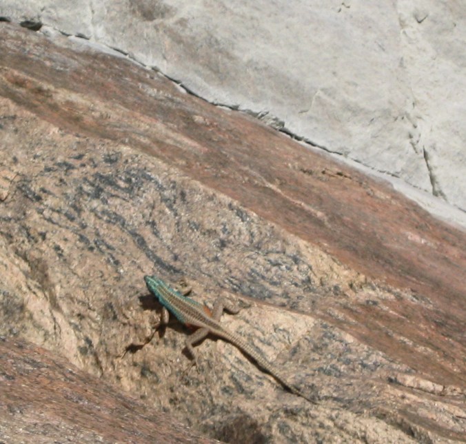
Koggelmander – The Southern Rock Agamas atra photo by Morag Noffke, Augrabies Falls


- Koggelmander – The Southern Rock Agamas atra photo by Morag Noffke, Augrabies Falls
We saw many kogglemanders basking in the sun on the rocks and in the late evening we were stunned by the view overhead: the black sky and the stars. The following morning the wind started up, convincing us to move on. I am able to tell what the weather is doing when I look up at the sky and watch the clouds in my home town but I felt out of my depths being in foreign territory – there is no way to tell what the weather is doing. Unbeknownst to us this wind was bringing the rain in behind us.
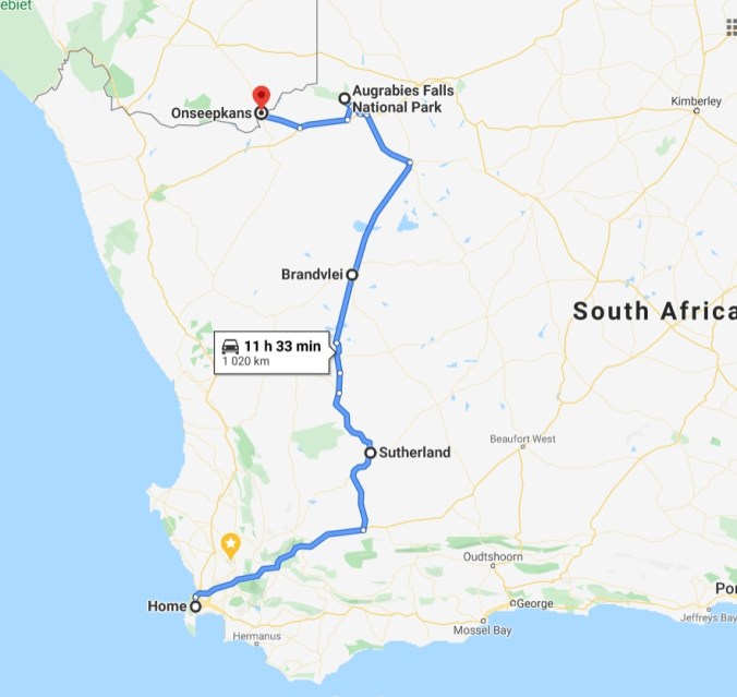
Our route from Cape Town to the border between South Africa and Namibia. On the forth day we had planned to travel further and camp inside Namibia but we got lost. As you can see the forth leg is a lot shorter than the others. 2013
As we drove the GPS was giving some very odd suggestions. We had named the GPS ‘W’, insert your name of choice. I am sure many of you have named your GPS. Well ‘W’ told us to turn right at farm fences on a number of occasions and to turn at a dry river bed. ‘W’ was struggling as we were now moving into real wilderness terrain where roads had not been captured on the system. We were driving on dust roads with no sign boards and were not aware of how badly we were going to be lead down the “farm” path when we realized we were lost.
We had to double up on our route and it took us much longer than expected. This is how we landed up staying in a guest house, out of the rain just inside the South African border. The next day we crossed the South African/ Namibian Border and went onto a whole new adventure.
That’s is a story for the future.
Cheers.
An African adventure began to stir in our hearts.
An African Adventure: Cars and equipment
An African Trip, Day 1: 30th May 2013
African trip, Facing my foibles, day 2
Our African trip: Eating simply
African trip: we were lost.

Reading this made me remember something. We too have had a similar experience in India on one of our road trips as a family. Glad all was well for you too. Our journeys unfold so much more than the path, and when sometimes paths are lost, new perspectives manifest.
LikeLiked by 2 people
That is so true 👍thank you!
LikeLiked by 1 person
It’s lovely that we can share similar experiences.
LikeLiked by 1 person
I don’t know how I would have reacted in a totally strange land, a lost GPS, dirt roads and to top it all off rain coming in behind us. You are one strong lady to have found a sense of adventure in such adverse circumstances. What an exciting read!
LikeLiked by 1 person
😊Thank you.
LikeLike
Pingback: Our African trip: Eating simply | Morag Noffke
Pingback: African trip, Facing my foibles, day 2 | Morag Noffke
Pingback: An African Trip, Day 1: 30th May 2013 | Morag Noffke
Pingback: An African Adventure: Cars and equipment | Morag Noffke
Pingback: An African adventure began to stir in our hearts. | Morag Noffke
Pingback: Scenes of the North Western Cape, en-route. | Morag Noffke
Pingback: African Trip: The quiver tree forest and Giant playground. | Morag Noffke
Pingback: Visting Etosha Nature Reserve. | Morag Noffke
Pingback: Back on the road, in Namibia. | Morag Noffke
Pingback: Poppa Falls: The ups and downs. | Morag Noffke
Pingback: A very eventful day in the Africa, 2013 | Morag Noffke
Pingback: Prince Sibeso at Zambezi River. | Morag Noffke
Pingback: An African Road Trip: Visiting Victoria Falls. | Morag Noffke
On our 4×4 camping travels, we often leave the track (as Berto think of it … it think more in terms of “loose the track” 😉), but then our sense for adventure takes over and we always think of these deviations as new places we’ve explored.
Looking at your photo’s of the Augrabies Falls, I think it must now be a spectacular sight to see since the last rain – apparently it’s doing its name justice of “place of great noise/thunder”.
LikeLiked by 1 person
Yes I saw a video of it now. Wow. I showed Derek and we both said.. Wish we were there to see it in person. But I even loved the geography of the area, just so amazing. I find landscapes speak to my heart and refresh my soul.
LikeLiked by 1 person